Thread #6377408

File: Untitled-3.jpg (1.2 MB)
1.2 MB JPG
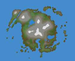
I'm making a map to use for world-building and I'd like help to make it as organically as possible. Here I have made the natural layout for a medium/large island; boringly similar to a European landmass like the UK. It is temperate with mixed dense forests, large mountains, and giant freshwater lakes similar to the NA great lakes. Geologically its probably formed from a combination of ancient volcanic activity and glacial erosion.
I'd like you guys to add details one at a time, like settlers and POI or maybe creatures or natives, that it builds up like a chronological history. Mundane or fantastical or serious or silly are all fair play, I'd just like to avoid completely illogical nonsense. Also feel free change the landscape in way that make sense on a human time scale, like shifting river and shoreline or man-made changes like farmland and clear-cutting.
3 RepliesView Thread
 Showing all 3 replies.
>>
>>
>>6377408
Rivers are coming from the middle mountains, I assume from melting snow.
This combined with the central location makes the mountains notably important for strategic and transit purposes.
So this leaves an important question: what is the name for the mountains, and who controls the area?
Now, separate of that... which way is the mainland? I ask because that would determine which side of the island would have the most import spot for a harbor / port.